A Sea You Can Walk Across to a Gate
The great torii gate of Miyajima (Itsukushima) stands in the sea.
The image of the vermilion gate floating on a full tide is famous. But when the tide goes out, you can walk right up to its feet. The base of the gate you approached by boat an hour ago is now reachable on foot, across wet sand. The same place looks like a different world.
There are useful tide markers. When the tide level rises above roughly 250 cm, the halls of Itsukushima Shrine appear to float on the sea. When it drops below 100 cm, you can walk out to the great torii gate. At spring tide, the difference between high and low water reaches about 3 meters (Miyajima Tourist Association).
Someone who arrives in the morning and someone who arrives in the evening are not looking at the same Miyajima. The Miyajima of the sea, and the Miyajima of the tidal flat. Both are the real one.
The Tide at Miyajima Is Set by the Shape of the Seto Inland Sea
What decides how far the tide falls at Miyajima is not really Miyajima itself, but the shape of the sea it faces — the Seto Inland Sea.
The Seto Inland Sea is not a sea open to the ocean on all sides. It is a long, half-enclosed sea, held between Honshu, Shikoku, and Kyushu. And it is not one smooth sheet of water. Wide, open stretches of sea and narrow channels squeezed between islands connect one after another, in and out along its length.
Where the sea is wide, the tide rises and falls by a lot; where it narrows, the tide runs fast. The reason the tide wears such a different face from place to place, even within one inland sea, is this uneven geography.
Two Mouths, and a Tide That Arrives Out of Step
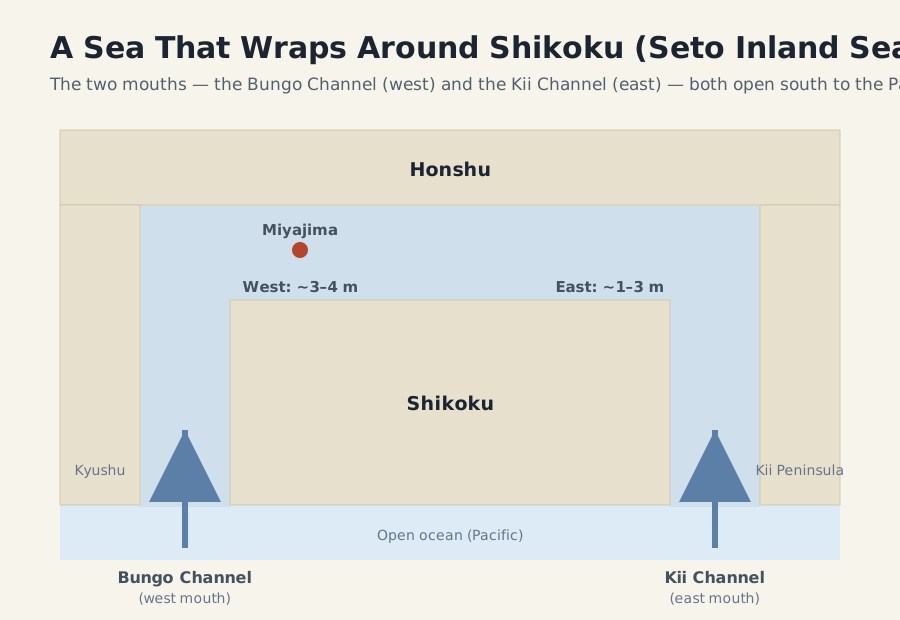
This half-enclosed sea connects to the open ocean through two mouths: the Bungo Channel to the west and the Kii Channel to the east. The Pacific tide flows into the inland sea through both of them.
The tidal range differs from place to place: roughly 1–3 meters in the eastern part, and 3–4 meters in the western part where Miyajima sits — larger the farther west you go (Ministry of the Environment, Setouchi Net).
Why does it differ by location? The key is the time it takes for the tide to arrive.
The tidal waves entering from the two mouths are amplified and delayed as they travel through narrow straits and bays. A tide entering from the Kii Channel takes as long as 5–6 hours to travel around Awaji Island and reach the other side. By then it meets, out of phase, the wave that came from the other direction. When two waves happen to add together at just the right timing, the swing of the water level grows larger. This is resonance (Ministry of the Environment, Setouchi Net).
The tide at Miyajima falls so far because, as a result of these two mouths, time lags, and resonance, the western part of the sea rises and falls by a large amount.
So why does the tide fall farther in the western part of the same inland sea? According to a recent modeling study, the tidal wave entering from the Bungo Channel and the one entering from the Kii Channel travel toward each other through the inland sea and collide around Hiuchi-nada, in the central basin. Where they meet and pile up, the tidal range reaches its maximum (Guo et al., 2013). Miyajima sits in this large-swing western region — which is why the tide falls farther here than in the east.
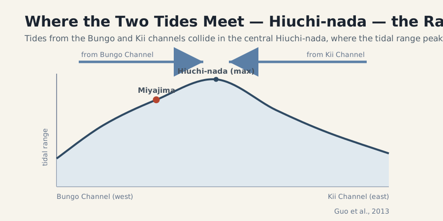
What is striking is that at Hiuchi-nada, where the range is largest, the tidal current itself is very weak, while the fastest currents occur in narrow straits like the Kurushima and Naruto straits (Guo et al., 2013). The place that rises and falls the most and the place that flows the fastest are not the same. The Naruto whirlpools belong to the latter.
We Measured It: Tidal Range Along the Honshu Coast
The theory is clear — but does the sea actually behave that way? Using the Japan Meteorological Agency’s published 2026 tide-table predictions, we picked ports along the Honshu coast from west to east at roughly even spacing, and tallied, for each, the largest tidal range of the year and the mean range. Tidal range here is the day’s highest tide minus its lowest, so it can be compared between ports regardless of each one’s chart datum.
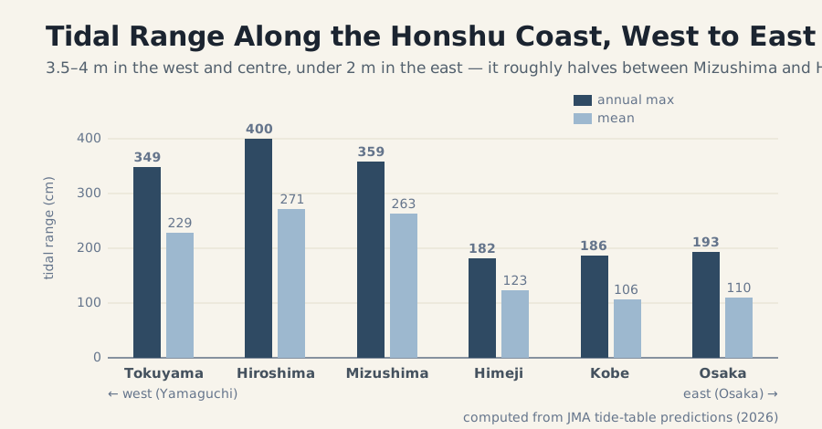
The result was unmistakable. From Tokuyama (Suo-nada) in the west through Hiroshima (Aki-nada) and Mizushima (Bisan-Seto), the annual maximum runs about 3.5–4 metres. But at Himeji (Harima-nada), Kobe, and Osaka in the east, it drops below 2 metres. Between Mizushima and Himeji, the range roughly halves. The boundary between the strongly swinging western and central sea and the barely swinging eastern sea shows up directly in the numbers.
Miyajima (Itsukushima) sits right in the middle of that strongly swinging western side. That is why the tide falls so far. Theory and measurement point to the same thing.
The Naruto Whirlpools Are the Proof
There is one place that shows the drama of this time lag most vividly: the whirlpools of the Naruto Strait.
Across the Naruto Strait, the Pacific side (the Kii Channel) and the Seto Inland Sea side (the Harima Sea) are out of step in their tides. When one side is near high water, the other is near low water. Because of this timing gap, a difference in sea level builds up between the two sides of the strait — as much as about 1.5 meters (Minami-Awaji City, how the Naruto whirlpools form).
Water rushes from the high side to the low side. The Naruto Strait is only 1.3 kilometers wide, with a V-shaped seabed about 100 meters deep. Through this narrow, deep channel runs one of the fastest tidal currents in Japan. The center is fast; the shallow edges are slow. That difference in speed twists into a spin, and whirlpools are born. This is why they appear only for a few hours around high and low tide.
The quiet ebb at Miyajima and the violent whirls at Naruto look like completely different scenes. In truth they are two faces of the same phenomenon. The tide enters through two mouths and passes itself out of phase — one face of that is the tidal flat at Miyajima, and the other is the whirlpool at Naruto.
A Tide Is Made of Time
Seen this way, the view at Miyajima is not a single picture.
It is a function of time. The height of the sea is set by the hour, by whether it is a spring or neap tide that day, by the position of the moon. So Miyajima shows a different face every time you visit. The gate on the sea and the gate on the tidal flat — neither one is the “real” Miyajima. The changing itself, all of it, is the landscape called Miyajima.
Postcards usually capture a single instant of high tide. But the real Miyajima lives in the slow rise and fall of water on either side of that instant.
A Miyajima That Shifts With Time, on Your Desk
Wakeikoku is a landscape desk clock app for iPhone that draws Japanese scenes not as static backgrounds, but as views that change with time.
The Miyajima scene added in version 1.3.0 depicts the daytime low tide and the quiet high tide of morning and evening — the bright hours of the exposed flat, and the hours when the water returns. It places Miyajima’s own nature, the way it changes expression with time, on a small screen on your desk.
Once you know how the tide at Miyajima rises and falls, that quiet motion may look a little different when you watch it.
Wakeikoku - Japanese Ambient Scenery
Related reading:
- Why Was Itsukushima Shrine Built on the Sea?
- Wakeikoku Articles: making-of, wadokei, and quiet time
- Japanese Landscape and Quiet Time: Mount Fuji and Kyoto
References
- Miyajima Tourist Association: How to Read the Tide Table
- Ministry of the Environment, Setouchi Net: The Seto Inland Sea
- How Seto Inland Sea tides converge at Hiuchi-nada to reach maximum range: Guo, X. et al. (2013) “Simulation of tidal currents and nonlinear tidal interactions in the Seto Inland Sea, Japan”, Reports of RIAM, Kyushu University 145, 43–52. Also stated in the open-access Dong & Guo (2024), Ocean Science 20, 1527–1546.
- Minami-Awaji City: How the Naruto Whirlpools Form

Wakeikoku
Keep a Quiet Japanese Scene on Your Desk
Wakeikoku turns your charging iPhone into a calm Japanese landscape clock with washi textures, ink scenery, stars, moon phases, and a modern wadokei mode.